


Semantic 3D city interfaces - Intelligent interactions on dynamic geospatial knowledge graphs
- GeoWeb 2.5 minimising deliberate misinformation risks while modeling critical infrastructures.
- Geographical Web Systems blending human and artificial intelligence during knowledge enhancement.
- Interactive interfaces to Dynamic Geospatial Knowledge Graphs.
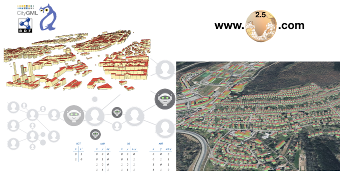 This article presents a system architecture and a set of interfaces that can build scalable information systems capable of large city modeling based on dynamic geospatial knowledge graphs to avoid pitfalls of Web 2.0 applications while blending artificial and human intelligence during the knowledge enhancement processes. We designed and developed a GeoSpatial Processor, an SQL2SPARQL Transformer, and a geospatial tiles ordering tasks and integrated them into a City Export Agent to visualize and interact with city models on an augmented 3D web client. We designed a Thematic Surface Discovery Agent to automatically upgrade the model’s level of detail to interact with thematic parts of city objects by other agents. We developed a City Information Agent to help retrieve contextual information, provide data concerning city regulations, and work with a City Energy Analyst Agent that automatically estimates the energy demands for city model members. We designed a Distance Agent to track the interactions with the model members on the web, calculate distances between objects of interest, and add new knowledge to the Cities Knowledge Graph. The logical foundations and CityGML-based conceptual schema used to describe cities in terms of the OntoCityGML ontology, together with the system of intelligent autonomous agents based on the J-Park Simulator Agent Framework, make such systems capable of assessing and maintaining ground truths with certainty. This new era of GeoWeb 2.5 systems lowers the risk of deliberate misinformation within geography web systems used for modeling critical infrastructures.
- This paper draws from preprint 297: Semantic 3D City Interfaces - Intelligent interactions on Dynamic Geospatial Knowledge Graphs
- Access the article at the publisher: DOI: 10.1017/dce.2023.14
Associated Themes:
![]()