

Defining archetypes of mixed-use developments using Google Maps API data
- We develop a methodology to understand mixed-use developments using master-planning data and Google Maps data.
- We formulate 163 mixed-use zoning archetypes in Singapore using machine learning methods.
- We demonstrate how these archetypes improve Urban Building Energy Modelling.
- We represent these archetypes as an ontology called ontoMixedUseZoning.
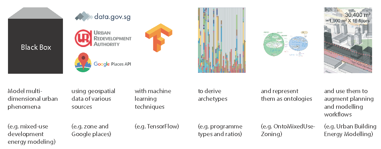 Urban planning relies on the definition, modelling and evaluation of multidimensional phenomena for informed decision-making. Urban building energy modelling, for instance, usually requires knowledge about the energy use profile and surface area of each use that takes place within a building. We do not have a detailed understanding of such information for mixed-use developments, which are gaining prominence in urban planning. In this paper, we developed a methodology to quantitatively define the characteristics of mixed-use developments using archetypes of programme profiles (ratios of each programme type) of a city’s mixed-use plots. We applied our methodology in Singapore, resulting in 163 mixed-use zoning archetypes using Singapore’s master plan data and Google Maps API data. In a case study, we demonstrated how these archetypes can be used to provide more detailed data for urban building energy modelling, including energy demand forecasts and energy supply system design. To enable future automation of the workflow, the archetype definitions were represented and stored as a machine-readable ontology. This ontology can later be extended with for example, the mobility properties of archetypes; thus, enabling the archetypes' use in other urban planning applications beyond building energy modelling.
- This paper draws from preprint 285: Defining archetypes of mixed-use developments for improved urban building energy modelling
- Access the article at the publisher: DOI: 10.1177/23998083221141428
Associated Themes:
![]()